As the fourth largest island in the world, Madagascar is also sometimes referred to as the “sixth continent”. More than 150 million years ago, Madagascar lost its hold onto the African continent. Due to this “isolation”, different animal species developed here than on the rest of the African continent. As a former “green” island, it lost a large part of its forested area due to the increasing population.
A high plateau with mountains (over 2000 m) in the centre is surrounded by rather flat plains, where the nutrient-poor soil is partly bright red, hence it is also called the “Red Island”.
Diego Dias, a Portuguese navigator was one of the first Europeans on the island. He was followed by the British, the Dutch and the French, who also took an interest in this corner of the world. As a result, the name changed a few more times over the coming centuries and was only settled on Madagascar in the 17th century.
After an exciting period as a pirate island, Madagascar had many individual rulers and kings during the 18th century. An important king named Andrianampoinimerina brought a large part of the island under his rule. The seat of government became the exciting city of Antananarivo in the central highlands. In the late 19th century, the island became a French colony. During this time, the infrastructure was developed in order to quickly transport the resources gained to Europe. Sugar, coffee and spices were the luxury goods for Europe. Madagascar has been a republic since 2010.
A short overview of the most beautiful sights and attractions of all kinds.
- Antanarivo – Visit the capital
Located in the central interior, this capital is considered one of the most beautiful in Africa. Spread over several hills and enthroned on the highest is the Rova, the old palace of the Queen. The highlands north of the capital Antananarivo are completely unwooded and are considered to be one of the most fertile regions; vanilla, sugar cane and coffee are the main crops grown here.
- Lemur Park – small zoological-botanical garden, as lemur reserve
This park covers 5 ha (50,000 sq m) and is located about 22 km southwest of the capital. Established around 2000, most of the nine species of lemurs represented move freely within the park area. More than 70 endemic plant species also make it an ecological jewel. The park is open to the public and also offers guided tours. There is a private park shuttle from Antananarivo.
- Nosy Sakatia – A quiet little island
Ten minutes directly in front of the west coast of the main island Nosy Be, this small neighbouring island invites to extensive walks and beautiful boat trips, it is also a true paradise for enthusiastic divers.
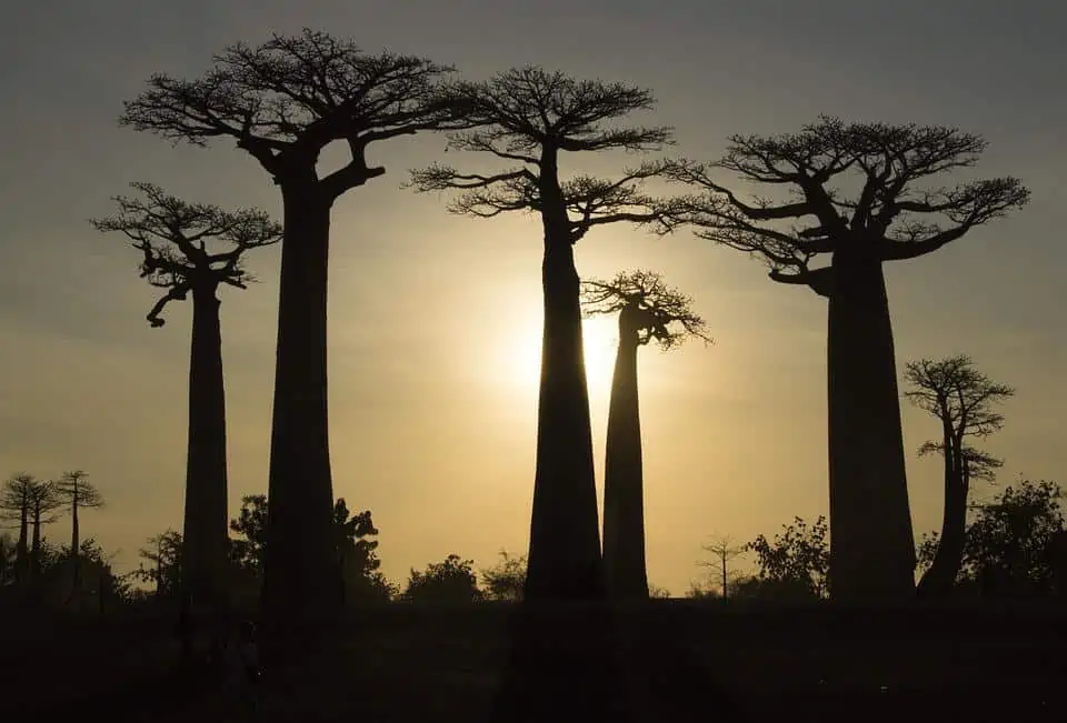
- Baobab tree – avenue – entrance to the harbour town of Morondava
This town on the Mozambique Channel is located 700 km southwest of the capital in the Menabe region. It is a good starting point for various unique and eventful day trips. The Kabatomena, a river that flows into the Mozambique Channel at Morondava, is a blessing for the agricultural economy as it provides water for the large plantations all year round.
- Tsingy Rouge – sandstone formation
The red Tsingy are located in the north of the island, about 50 km from Diego Suarez. Compared to the Tsingy de Bemaraha (which are grey in colour) in the west, these are made of sandstone and not limestone. The reddish colour of this formation is due to the red sensitive laterite soil that is so typical of Madagascar. These peaks of sandstone are constantly changing due to erosion by wind and water. They are up to 10 metres high and shine in a wide variety of red tones. They can be seen up close from the edge of the canyon as well as by descending into the canyon. This sandstone formation was only exposed by landslides in the middle of the 20th century
- Tsingy de Bemaraha National Park
This Bemaraha National Park is famous for its bizarre limestone rock formations, the Tsingys, which have been declared a World Heritage Site. It is located in Mahajanga Province and Antsalova District. It has been part of the UNESCO World Heritage Site since 1990.
On round trips through Madagascar, you are spoilt for choice – or you can take the best of everything! Whether hiking tours, cultural encounters and nature observations or relaxing on the beach, snorkeling tours, whether rainforest or thorny semi-desert, whether mountainous tropical forests or endless plains, everything is available on this island. Due to the wide range of activities, the beautiful beaches almost disappear from sight. If you are lucky, you may spot the fossa (Cryptoprocta ferox), a predator native to Madagascar, in one of the reserves. It is the largest predator on its home island and feeds primarily on primates and other kinds of mammals.
And by the way, Malagasy cuisine is quite simple, but delicious…